Shocking Satellite Images Reveal Devastation at Fordow After US Bunker Buster Strike!
Satellite Images Show Extensive Damage to Iran’s Fordow Nuclear Facility After US Strikes
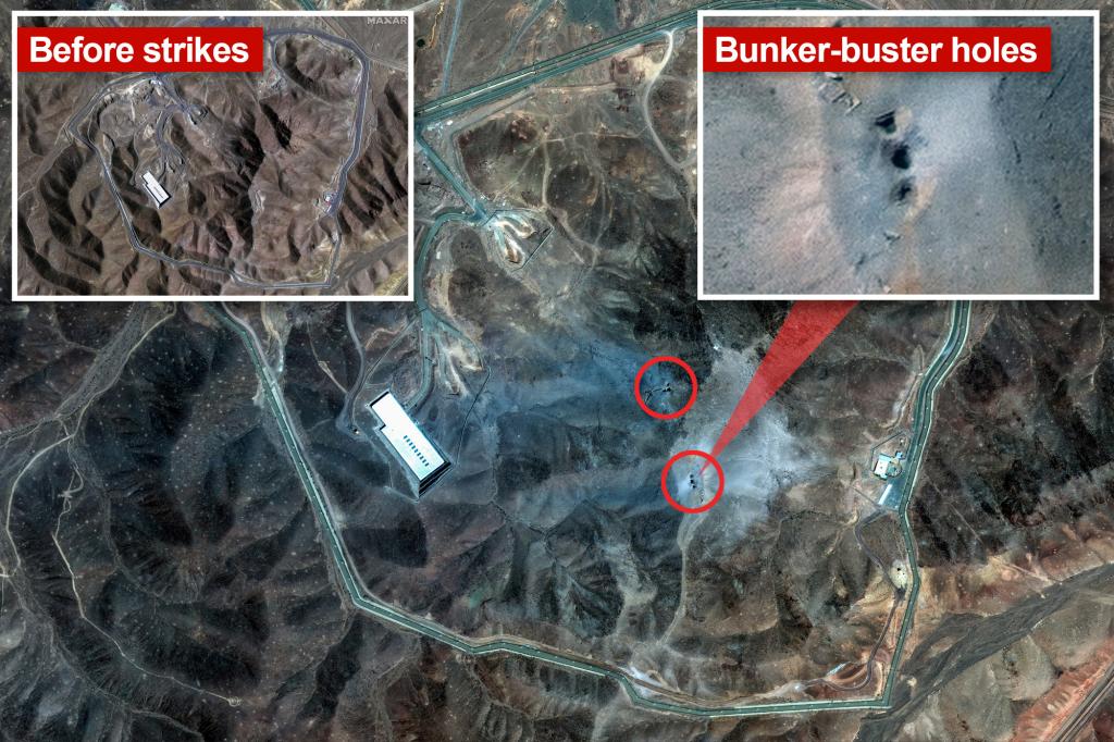
Recent satellite imagery reveals that a portion of Iran’s Fordow nuclear enrichment site has been destroyed, likely as a result of a US bunker-buster bomb attack. The images indicate that part of the mountain sheltering the underground complex has been completely flattened, with visible entry points and debris suggesting structural collapse.
Following a surprise overnight raid by US B-2 stealth bombers, high-resolution images display the topography of the mountainous area dramatically altered by the detonation of 14 massive bombs, each weighing 30,000 pounds. The terrain has shifted from brown to gray, with significant craters and holes in the landscape.


Satellite images also show a layer of light gray smoke lingering above the site, located approximately 100 miles south of Tehran. It appears to have been sealed off prior to the attack, with Iran reportedly evacuating the region beforehand. Officials claim all nuclear materials, including enriched uranium, had already been removed from the site, minimizing radiation risks.

It is believed that the US and Israel targeted the complex with the aim of causing a cave-in or structural subsidence, effectively rendering the site inoperative. Given its size—covering around 54,000 square feet and housing about 3,000 centrifuges—Fordow was considered a significant nuclear installation. Iran’s government has yet to release an official damage assessment.
While Israel lacks the capability to single-handedly hit Fordow, the US utilized the GBU-57, a bunker-busting bomb capable of penetrating 200 feet underground, to achieve the strike. Developed in the early 2000s, this bomb can destroy deeply buried facilities by penetrating rock and concrete before detonating.