Stunning Satellite Images Reveal Devastation at Fordow After US Bunker Buster Strike—You Won’t Believe the Damage!
Satellite Images Reveal Extensive Damage to Iran’s Fordow Nuclear Facility
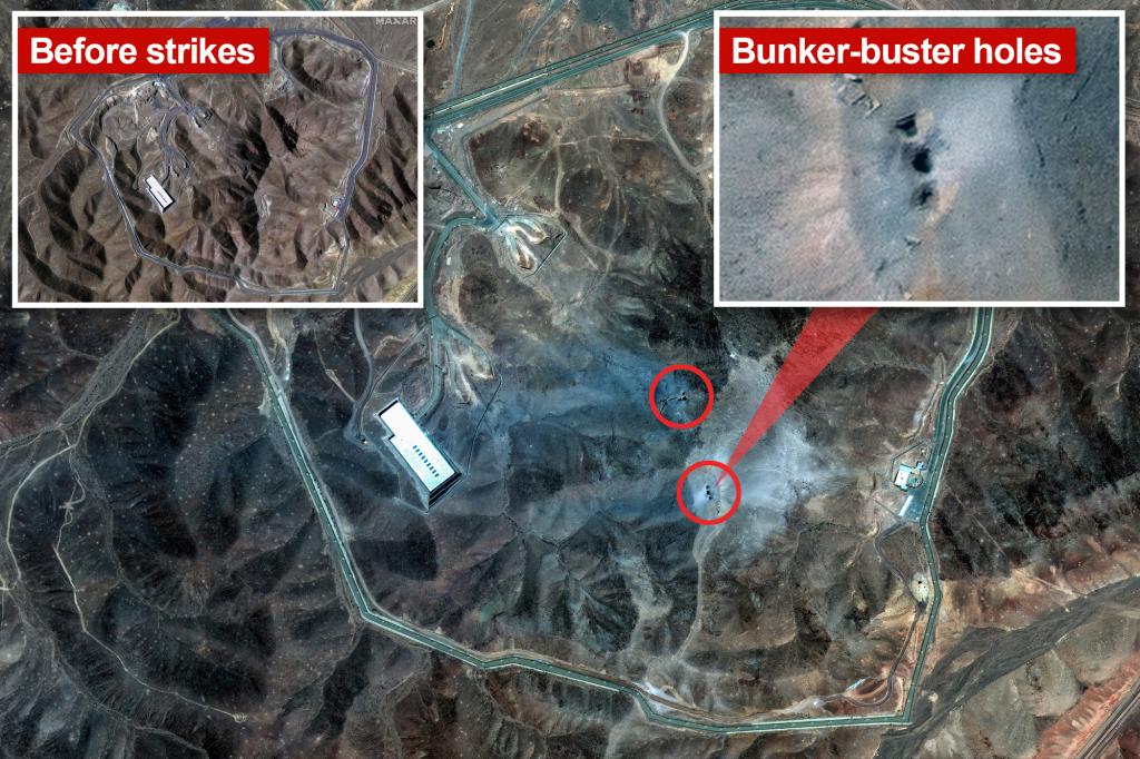
Recent satellite imagery indicates that Iran’s Fordow nuclear enrichment site has suffered severe destruction. Parts of the mountain concealing the underground complex were completely destroyed after a targeted strike using US bunker-buster bombs. Experts note significant structural collapses within the facility.
Images captured post-attack show possible entry points for bombs and debris scattered around the site. The landscape has shifted markedly, with the mountain’s surface turning from brown to gray due to the detonation of 14 Massive Ordinance Penetrator (MOP) bombs, each weighing 30,000 pounds.

After the attack, large craters and damaged mountain sections are visible, with smoke lingering in the air around the site, located approximately 100 miles south of Tehran.

While Iran has not issued an official damage assessment, they reportedly evacuated the site in advance, transferring nuclear materials to other facilities. Officials confirmed that no hazardous materials remain at Fordow, reducing radiation risks from the attack.
Built deep beneath a mountain near Qom, Fordow was targeted to cause cave-ins or subsidence, effectively sealing off the underground tunnels. Military sources suggest the operation aimed to collapse the tunnels’ structures, with satellite images showing evidence of sealed entrances and significant structural failure.
At around 54,000 square feet, the site once housed approximately 3,000 centrifuges. U.S. and Israeli forces collaborated, with the US deploying GBU-57 bunker-busters capable of penetrating up to 200 feet underground before detonation.
Additional satellite images depict damage near Iran’s second-largest city, Isfahan, where several buildings have been obliterated, marking a broad and impactful strike on Iran’s nuclear infrastructure.
